In San Luis Valley, an Artist Demystifies the Complex Hydrology Behind a Community’s Chronic Water Shortage
Colorado’s San Luis Valley lies in the imprint of an ancient lake, long dried. Its borders are the ring of mountains once its shores, and beneath its surface lies the vast web of the Rio Grande Aquifer. This aquifer sustains the largely agricultural economies of San Luis Valley’s five counties. But increasingly, it struggles to do so. Demand for water has outpaced the basin’s supply since the turn of the 20th century, and its water flow has now been in decline for over 25 years. As the stakes to reduce water usage rise, local artist and conservationist Jocelyn Catterson uses art to help her community understand the nuances impacting the aquifer and the region’s livelihood.
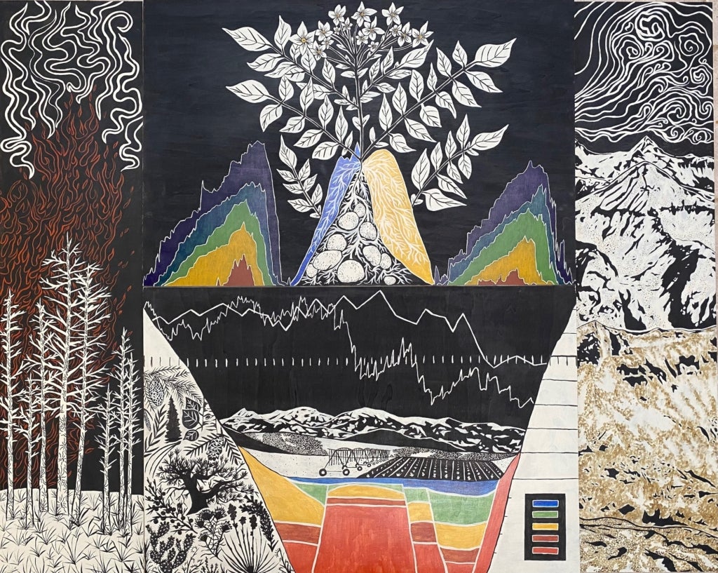
“Making the Invisible Visible” is a series of three data-driven paintings that communicate the intricate ecosystem factors driving water depletion in the San Luis Valley. “A lot of the general public in the San Luis Valley does not really know or understand what’s happening with the aquifer. It’s a really intangible concept because we can’t see it,” said Catterson. She said that art helps people visualize the complex but hidden environmental issues unfolding around them.
The project began in 2022 when Catterson was selected as a Colorado Art Science and Environment (CASE) Fellow through the University of Colorado Boulder. The fellowship is designed to bring together artists, scientists, and communities to communicate how the interconnected issues of fire, drought, and water and air quality impact Coloradans.
It was not difficult for Catterson to choose her topic. “In the San Luis Valley, water is by far—in my opinion—the most pressing issue,” she said.
Water plays a critical role in the valley’s economy and its supply is not guaranteed
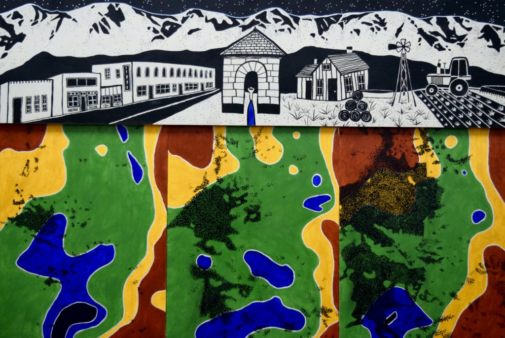
According to the 2022 Rio Grande Basin Implementation Plan (BIP), nearly a third of jobs in the valley come from the agricultural industry, which accounts for 99 percent of total water use in the Rio Grande Basin. Agriculture’s central role in the economy and its heavy reliance on both groundwater and surface water resources means everyone in the community feels the impact of water scarcity, regardless of their involvement in farming.
One particularly tangible incentive for the community to reduce its water usage came in 2012. That year, the state granted communities the opportunity to self-govern their water use with the goal of replenishing the valley’s aquifers to state-defined sustainable levels by 2031. The region leaned into the opportunity by creating water management subdistricts to oversee and regulate water use at the local level.
Subdistrict 1 is of particular importance. It sits atop the valley’s unconfined aquifer and is home to some of the area’s largest farms. It is also at great risk. Though the state has stepped back for the time being, it still has eyes on the valley. If self-governance does not restore water supply by the start of the next decade, the state will step in and shut off the flow of water to thousands of wells. These could include some of the 3,000 wells supplying water to farms in subdistrict 1.
The valley is relying on a whole-of-society approach to save its water supply
People are coming together to meet the 2031 goal. In 2018, subdistrict 1 faced a setback when drought conditions drove the aquifer to one of its lowest points ever recorded, but Catterson said that in 2024, the community pumped less water than it has since the it began recording its usage. “Our community is working really really hard to decrease the amount of groundwater that we’re using,” she said.
Though the aquifer and surface water flow continue to decline, nobody faces the issue alone. The creation of subdistricts has brought the community together. At subdistrict roundtables, environmentalists, farmers, and ranchers all join forces to plot the future of water use in the valley.
Catterson’s work has also been welcomed into the movement. “That’s a really important part of this project and this story: that it would not have been as successful if it was not for the really supportive and collaborative nature of the water community down here in San Luis Valley,” she said.
Community research and feedback are the basis for Catterson’s artwork
Much of Catterson’s fellowship was spent on research. She said she dedicated the first six to eight months of the project learning and collecting data. She interviewed farmers, ranchers, hydrologists, scientists, and others to learn what data and visuals they thought were important in telling the story of water in the San Luis Valley. When she had gathered her initial thoughts on what to include, she returned to her interviewees to hear their insights into what she had and what might still be missing.
Through this process, Catterson was surprised to learn how many different variables come together to impact the region’s water supply. Among those were environmental issues occurring miles away. Many of these are outlined in the Rio Grande BIP.
Dust and beetles play a surprising role in the valley’s hydrology
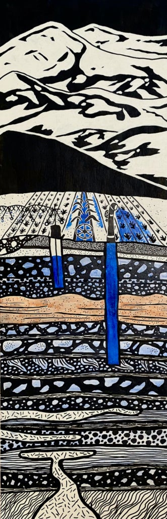
San Luis Valley relies heavily on snowmelt from the surrounding San Juan Mountains and Sangre de Cristo Range. Many factors can impact flow from the peaks to the valley floor, but one lesser-known influence is that of dust on snow. This phenomenon occurs when desert dust blows into snow covered areas and settles on the snowpack. Snowmelt is the primary driver of the Rio Grande Basin’s hydrology, so changes in snow accumulation in headwater areas have a significant impact on groundwater and flow downstream.
Dust on snow impacts the area’s hydrology in several ways. First, the dust is darker than snow, thus absorbing more heat and causing the snow to melt faster. Its impact can speed up a season’s melting process by several weeks. This then allows plants to germinate earlier, meaning they have a longer season in which they are extracting water from the soil. These evapotranspiration losses can decrease annual runoff by about five percent of the annual average flow.
Beetles are another piece of the puzzle. Since the early 2000s, Colorado forests have suffered infestations of spruce bark beetles. The insects burrow into the trees, damaging their vascular systems and eventually killing them. This decreases the overstory, which impacts snow accumulation, melting, evapotranspiration, runoff, and more. These impacts are long-term, as forests can take decades to fully recover from large die-offs.
Other factors are at play as well, including chronic drought and more frequent and severe wildfires.
This complex web of factors is both driven and exacerbated by climate change. For example, increased temperatures further accelerate snowmelt and evapotranspiration in areas already affected by dust, and trees in water-stressed forests are more susceptible to beetle infestations.
It was important to Catterson that her work reached both state and local audiences
While the final series comprises three paintings, Catterson knew only one would be displayed in the state capitol building at the end of the project. Thus, the largest of the three can also stand alone. “I wanted to make sure that the full story could be told within one painting that the governor, and different representatives, and the general public were going to see on display at the capitol building,” she said.
Catterson wanted the paintings to reach people beyond the capitol building, too. If art is to make scientific topics more accessible, it must live in accessible places. Through the CASE fellowship, Catterson traveled to several events to present and speak about her art, but she also wanted to bring the conversation to her own immediate community.
“While the paintings were touring around the state of Colorado, I really wanted to make sure that the information and the conversations were happening here with the local community in the San Luis Valley as well,” she said.
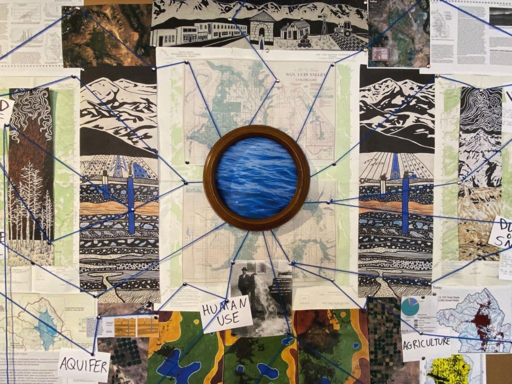
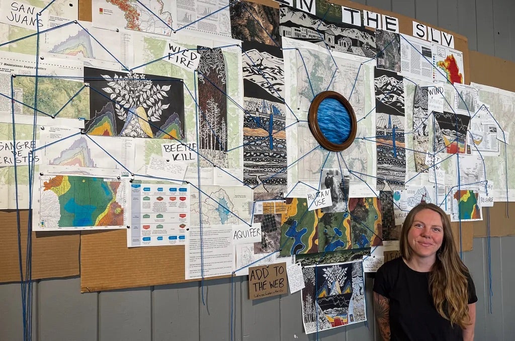
Catterson got permission from a local coffee shop to put up an installation she called a water web. She covered an entire wall of one of the most popular coffee shops around with reproductions of her paintings, data, photos, and writing, then used string to connect the different parts, showing how aspects of the environment impacted each other and the water supply.
The strategy to reach her community worked.
“Sometimes I would go in there and people maybe wouldn’t even know I was the artist and [I would] sit and overhear conversations between people looking at the data,” said Catterson. “I think the visualization of the connection helps people a lot.”
She has received an equally positive reaction to the initial series. She has seen it resonate with water experts and laymen alike. The scientific community appreciates it for its accurate representation of complex water issues in the valley and it helps people, including children, without a science background connect with the information without getting lost in jargon or graphs.
The paintings continue to tell their story long after the close of the fellowship
Catterson’s fellowship ended two years ago after a stop in Durango for the Four Corners Climate Summit, but she continues to use the works to educate people across Colorado. Their permanent home is in the office of the Rio Grande Water Conservation District in Alamosa and she still uses them and the knowledge she gathered to give presentations.
Sometimes opportunities to share the paintings come through her work as community engagement director for the Rio Grande Headwaters Land Trust. Other times she speaks in her individual capacity, leveraging the ties she has made in a tight-knit community.
Her work is welcomed by those around her, and she sees this as part of a larger trend that is bringing all hands on deck to face one of the region’s most pressing and urgent issues.
“Everybody just really knows that we all need to work towards this together,” said Catterson. “That is part of the reason that people have been so receptive to the art and science concept down here. Because they want everybody to have a seat at the table … because everybody needs to work together to try and solve this problem.”
More about the artist
Jocelyn Catterson is a multidisciplinary artist and environmental educator based out of Del Norte, Colorado. Jocelyn’s intricate, place-based works are rooted in the ecological and agricultural landscapes of the San Luis Valley. Her art explores the visual rhythms of natural systems through detailed, layered compositions that integrate natural history, science, and storytelling. Her practice is deeply tied to the landscape, using art as a tool to translate environmental data and field observations into research-driven visual narratives. In 2024 she began working as the community engagement director for the Rio Grand Headwaters Land Trust.
To see more of Jocelyn’s work follow her on Instagram @artofjocelyncatterson and visit her website at jocelyncattersonart.com.